


Project Highlights:
- Development of software utility to convert file formats for direct database importing.
- Conversion of over 5,000 borelog and 350 monitoring well files.
- Personnel training for use of the GIS database system.
Project Description:
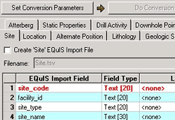
EQuIS is the environmental database of the USACE, Far East District (FED). It holds over 5,000 borelog and 350 monitoring well files, previously in LogDraft and GeoSystem file formats. In conducting this project, Environet's aim was to convert these files into a comma-delineated format, which can then be directly imported into the geology module of EQuIS.
Environet successfully programmed a software utility capable of converting the LogDraft/GeoSystem formats into a comma-delineated format, and also provided training to end-users at the USACE and the Samsung Corporation, who is a major provider of engineering services to the Far East District. During the training sessions, end-users were guided through each step involved in converting files and importing them into EQuIS. Furthermore, they learned how to export the EQuIS database information into the Department of Defense Groundwater Modeling System to allow creation of three-dimensional views and animations of borelog, water level, water quality, geotechnical, and soil contaminant data.
Harnessing the power of the most efficient technologies is a philosophy that the staff embraces at Environet. It makes sense to make the most of the dynamic resources available in today's market, and therefore Environet continuously strives to utilize these technologies whenever possible and practical.